
La Niña Returns: Will It Impact 2024 US Growing Season?
Just one year after the development of El Niño brought encouraging results to the 2023 growing season, forecast models suggest it will weaken this spring and that La Niña will return once again. The impacts on the 2024 growing season could be significant, but the details are still unclear at this lead time.
ENSO conditions refer to the periodic oscillation between water temperatures in the equatorial Pacific Ocean. Warmer than normal temperatures are associated with an El Niño and colder than normal ocean temperatures are associated with a La Niña. The oscillations and periodicity typically is one to two years, but as we have seen recently this can vary wildly.
LA NINA RETURNS…AGAIN
If you are feeling like we just emerged from La Niña conditions, you’re correct. La Niña was the dominant player in the tropical Pacific Ocean for almost three years before weakening in 2023. El Niño then took over last spring and summer, and the changes to the pattern were well forecasted. After three years of building drought and warmth, the pattern shifted from late spring into the summer of 2023 leading to more widespread moisture and a strong close to the growing season and harvest.
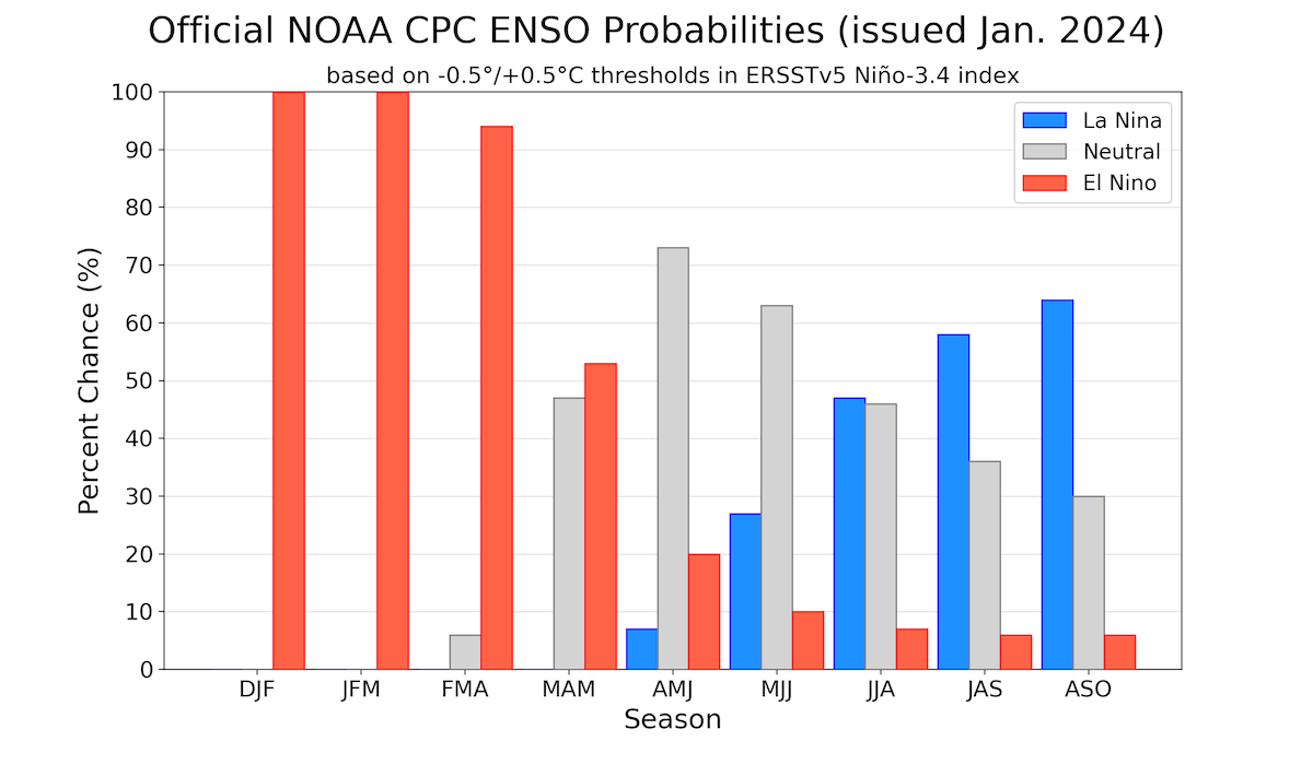
CPC forecast ENSO probabilities.
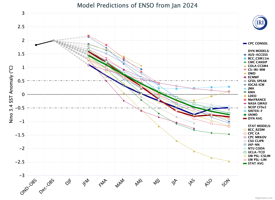
Now, we’re heading back towards a La Niña – and agreement among forecast models is strong. In fact, almost all long range model guidance suggests that La Niña is coming. The critical component to the forecast will be when it occurs and how quickly the transition takes place. This will ultimately have a major impact on the evolution of the weather pattern during the 2024 growing season. Right now, there is a great deal of spread among weather models in regards to the speed at which El Niño decays and La Niña redevelops.
It is no secret that the ENSO state has major impacts on the growing season in the United States and elsewhere. El Niño years are typically tied to more active weather and precipitation in the United States corn belt, while La Niña typically results in the expansion of drier and warmer weather with concerns for drought. This adds an additional layer of concern for the speed at which this new La Niña develops, as many areas simply have not had enough time to fully recover from the last prolonged drought.
In fact, looking at analog years from the past that featured a weak or moderate La Niña, we can clearly see why so many folks are sensitive to the development of La Niña overall. In the United States, there is a strong correlation between La Niña development and below normal precipitation during growing season. It should be noted that this correlation is particularly strong during the second half of the season.
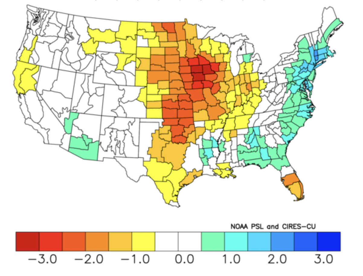
Precipitation departure from normal during La Niña years.
In other words, the middle and back half of La Niña years (June-August) tends to be particularly dry. This makes sense given what we know about La Niña patterns – they tend to encourage the development of drought. In addition, they cause strong Elevated Mixed Layers (EML’s) to emerge from the higher elevations of the Intermountain West and Mexico. These sprawling pockets of warm air aloft act like a lid in the atmosphere and suppress convection (thunderstorms), further exacerbating drought issues and mitigating thunderstorms overall.
Still, there are many other factors that affect the forecast aside from ENSO and conditions in the tropical Pacific Ocean. Sea surface temperatures in other bodies of water across the globe, as do the resulting jet stream patterns in the United States. For example, we’re also closely monitoring the water temperatures in the North Pacific, off the coast of California, in the Gulf of Mexico, and in the Northern Atlantic Ocean. All of these will contribute to help us figure out the story that the atmosphere is trying to tell us as we move into spring.
A WAITING GAME FOR NOW
While confidence is building in the development of La Niña as we move into the 2024 growing season, there are still many more questions than answers at this juncture. The speed at which the El Niño decays and La Niña takes over is still wildly uncertain. This will have a major impact on the conditions that we experience across North America and ultimately in the United States agriculture regions.
In a very general sense, a faster developing La Niña would not be good news. This would likely introduce the potential for drier and warmer weather to emerge across United States crop regions by the late spring or early summer months, reintroducing drought risks and presenting concern for crops. A slower developing La Niña would likely still come with some issues, but moisture would linger across key areas longer into the spring and summer.
At this range, the number of analog years we can use (years in the past that are progressing similar to this one) is quite limited. This means we will be proceeding with caution into somewhat “uncharted” territory once again during the 2024 growing season. You will likely begin to hear a lot of hype and nonsense on social media as news outlets grab hold of the potential for La Niña to return. Our advice is to ignore it and stay the course. We simply don’t know how this will impact the country, let alone local crop regions.
Confidence should begin to increase as we move through February and towards March, at which point we can start preparing for what’s to come. If you’d like to work with us this growing season, you can sign up here or shoot us an email.
More updates soon!
