

Meteorological spring is here: What happened this winter, and what lies ahead?
Meteorological spring begins today, marking the end of one of the warmest winters on record across the United States. Driven by the presence of a strong El Niño, the winter of 2023-2024 was very warm and noticeably lackluster in terms of snowfall nationally. What can we learn from this winter and how can it help guide our forecast into spring?
The primary driver of the weather this winter was the presence of a strong El Niño, characterized by the warmer than normal water temperatures across the equatorial Pacific Ocean. Strong El Nino’s are often associated with very mild conditions across the US during the winter season, and this winter was no different.
REVIEW OF WINTER ’23-24
Ridges of high pressure provided a mild start to the winter season across the US. The active Pacific jet stream aided in the development of a series of storm systems that brought increased precipitation across the Northern Plains, while much of the Midwest and Ohio Valley ran drier than normal. This ridge shifted north into early January, setting up a negative North Atlantic Oscillation (-NAO).
This -NAO, combined with riding across the North Pacific, lead to a cross polar flow and pushed arctic air south into the US. This led to a period of significant cold with temperature anomalies 20-40° below normal for a 10-15 day period in early to mid-January. This pattern also produced multiple winter storms across the C. Plains and Midwest with increased snowfall.
Since then, the pattern has been very mild across the Canadian Prairies and United States due to the lack of high-latitude blocking, with much warmer than normal conditions. Overall, it was the warmest winter season on record across much of the Midwest and Great Lakes and the top 5 warmest across parts of the Ohio Valley.
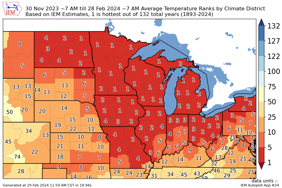
Temperature ranks: December 1st, 2023 – February 28th, 2024
This very mild pattern also impacted snowfall, or the lack thereof. For the US, it was the second -least snowy winter in the last 16 years with below normal across much of the Midwest and Ohio Valley. The colder pattern back in January did provide near to above normal snowfall across the C. Plains.
In terms of precipitation, since the beginning of 2024, many climate districts across the Midwest are running in the top 20 driest, with some areas in the top 10. Multiple storm systems kept the pattern active along the Front Range and Central Plains with many districts reporting 20 wettest.
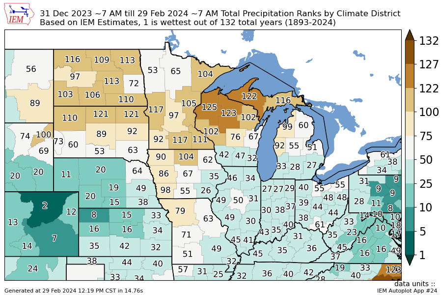
Precipitation ranks: January 1st, 2024 – February 28th, 2024
This lack of precipitation (rain and snow) is impacting soil moisture. Latest satellite derived soil moisture analysis shows very dry conditions across the Midwest and Ohio Valley. The heavy precipitation across the Northern Plains back in December helped provide a moisture reservoir but has since become drier than normal. Much of the Central Plains display a mixed profile with near normal conditions.
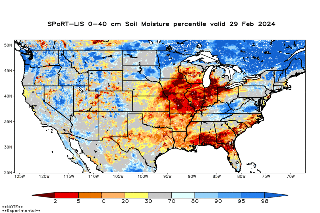
SPoRT soil moisture analysis valid February 29th, 2024
LA NINA UPDATE
Recent observations show El Nino continues to rapidly fade and cooler water is lurking just below the surface across the eastern Pacific. This is likely to emerge with cooler anomalies showing up in the next couple of weeks. The latest forecast models have trended cooler with the onset of La Nina conditions by summer.
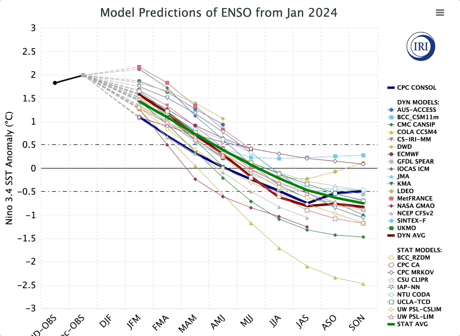
IRI ENSO forecast: trending colder into La Nina mid-late summer 2024
As discussed in previous blogs, the transition from El Nino to La Nina often leads to an active pattern across the US with the spring season. This idea has not changed and models continue to support a more active pattern across the agriculture belt with above average precipitation. This is also supported by our analog guidance with increased precipitation and a potentially active severe weather season.
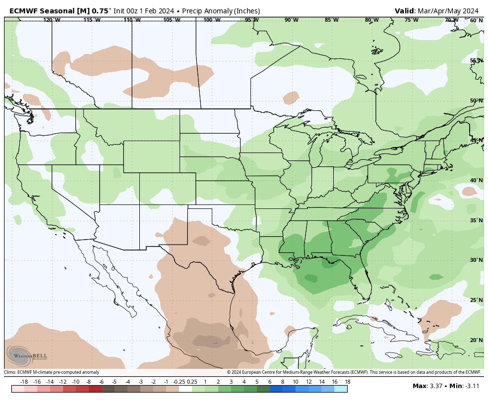
3-month European seasonal precipitation outlook for March, April, May 2024
Planting delays are still difficult to pin down at this range. Still, where there is an abundance of moisture there may be some area that could experience delays. We’ll continue to closely monitor this pattern in the coming weeks.
If you are looking for more information, we offer a wide range of comprehensive products to keep to ahead this growing season – no hype, just weather! Book a demo today.